Machida (Machida)
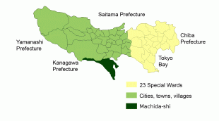
Machida (町田市) is a city located in the western portion of Tokyo Metropolis, Japan. , the city had an estimated population of 428,851, and a population density of 6,000 persons per km². The total area of the city was 71.80 sqkm.
Machida is located in the Tama Hills of southern Tokyo Metropolis, bordered by Kanagawa Prefecture on the west, south, and east approximately 40 to 50 kilometers from the center of Tokyo. The highest point is Mount Kusato (elevation 364 meters) at the western end. There are few flatlands near Machida Station, the Sakai River flows to the west and south, and the Tsurumi River flows almost in the center of the city.
Machida is located in the Tama Hills of southern Tokyo Metropolis, bordered by Kanagawa Prefecture on the west, south, and east approximately 40 to 50 kilometers from the center of Tokyo. The highest point is Mount Kusato (elevation 364 meters) at the western end. There are few flatlands near Machida Station, the Sakai River flows to the west and south, and the Tsurumi River flows almost in the center of the city.
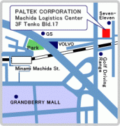
Map - Machida (Machida)
Map


Country - Japan
 |
 |
| Flag of Japan | |
Japan is the eleventh most populous country in the world, as well as one of the most densely populated and urbanized. About three-fourths of the country's terrain is mountainous, concentrating its population of 124.8 million on narrow coastal plains. Japan is divided into 47 administrative prefectures and eight traditional regions. The Greater Tokyo Area is the most populous metropolitan area in the world, with more than 37.2 million residents.
Currency / Language
| ISO | Currency | Symbol | Significant figures |
|---|---|---|---|
| JPY | Japanese yen | ¥ | 0 |
| ISO | Language |
|---|---|
| JA | Japanese language |